

Just a quick update: I don't have time right now to do justice to the subject.
Kevin Warner, the Douglas District Ranger, told a gathering (which filled the Portal Fire Station classroom) that walkers and cyclists can now enter Cave Creek Canyon. Most cars are not allowed in at this time.
Crews working on the Cave Creek Canyon Road, FR 42, have repaired a number of washed-out places already, but the entire job will take a long time. Kevin mentioned his hope that repairs will be finished in time for the 2015 birding season, beginning in March.
At this time, the Forest Service has begun to send a pilot car up the canyon twice a day, to guide workers to and from the Southwest Research Station, so that they don't have to make the long trip around through Paradise. Dawn is trying to get more flexibility in that arrangement.
Although Howard couldn't be present, we volunteered him to be the person who will collect updates from the Forest Service as repairs are made and roads are reopened, and post them to the Portal-Rodeo website. That website address is given here in my sidebar under "Links".
Showing posts with label Southwest Research Station. Show all posts
Showing posts with label Southwest Research Station. Show all posts
Wednesday, September 24, 2014


Monday, September 22, 2014
SWRS Survives the Flood, But Can It Survive the Road Closure?
The Southwest Research Station finds itself in a difficult position, caught between the financial demands of its parent company, the American Museum of Natural History, and the US Forest Service, which is enforcing a road closure that will likely exclude the station's workers and guests from access into Cave Creek Canyon via the damaged road.
I should wait until after Wednesday's meeting to report on the USFS closure policy: it should be clarified then. Right now I'm getting conflicting information about who will be allowed to travel on the main canyon road.

The research station's big problem is loss of revenue. They are having to cancel some groups, and are trying to maintain others due to come through October. The big fire hit in 2011, and now the big flood. Their fear is that the American Museum of Natural History will decide that the research station isn't worth the trouble, particularly if the station fails to break even financially.
Not only the flood, but also the road closure, will most definitely impact the station's bottom line. It appears that the Forest Service will insist that the station's workers and guests travel an alternative route through Paradise and up East Turkey Creek, then back into Cave Creek Canyon from the top. Not only does this route add an extra 45 minutes of travel in each direction, but the small cars of a number of the station's workers can't ford the stream crossings along that route. Today and tomorrow, the SWRS van is meeting its workers in Portal, and ferrying them to work via the Turkey Creek route. However, this is not a viable solution. It imposes too great a hardship. In addition, East Turkey Creek itself is prone to wash-outs, and people staying at the research station could easily become stranded by the closure. In an emergency, that would be disastrous. The proposed alternative could be more dangerous than the damaged road. And then there are the station's guests to consider....
SWRS is vital to Portal's well-being. The station is also important to researchers and students from around the world. It may be time to tell our representative, Ron Barber, and the Arizona Senators that we need help here. After Wednesday's meeting, we'll be in a better position to know exactly what help to request from them!

How does SWRS look after the flood? Fantastic.
The main problems have been lack of electricity, which Columbus Electric handled as soon as they could, and the continuing lack of phone and fiber optic cable for communications.

When the flood happened, 35 people were staying at SWRS. Electricity went out, and the supply of bottled water for drinking only lasted a day and a half. After that, the station boiled water taken from the swimming pool for drinking. Very soon, Dawn Wilson, the station's director, was able to traverse the road with Ray Mendez, and she brought back the needed generator and most essential supplies. The station's guests were evacuated as soon as it was possible to do so safely.


I should wait until after Wednesday's meeting to report on the USFS closure policy: it should be clarified then. Right now I'm getting conflicting information about who will be allowed to travel on the main canyon road.
Dining room at the Southwest Research Station yesterday, completely intact after the flood (Photos by Narca)
The research station's big problem is loss of revenue. They are having to cancel some groups, and are trying to maintain others due to come through October. The big fire hit in 2011, and now the big flood. Their fear is that the American Museum of Natural History will decide that the research station isn't worth the trouble, particularly if the station fails to break even financially.
Not only the flood, but also the road closure, will most definitely impact the station's bottom line. It appears that the Forest Service will insist that the station's workers and guests travel an alternative route through Paradise and up East Turkey Creek, then back into Cave Creek Canyon from the top. Not only does this route add an extra 45 minutes of travel in each direction, but the small cars of a number of the station's workers can't ford the stream crossings along that route. Today and tomorrow, the SWRS van is meeting its workers in Portal, and ferrying them to work via the Turkey Creek route. However, this is not a viable solution. It imposes too great a hardship. In addition, East Turkey Creek itself is prone to wash-outs, and people staying at the research station could easily become stranded by the closure. In an emergency, that would be disastrous. The proposed alternative could be more dangerous than the damaged road. And then there are the station's guests to consider....
SWRS is vital to Portal's well-being. The station is also important to researchers and students from around the world. It may be time to tell our representative, Ron Barber, and the Arizona Senators that we need help here. After Wednesday's meeting, we'll be in a better position to know exactly what help to request from them!
Cabins at the Southwest Research Station
How does SWRS look after the flood? Fantastic.
The main problems have been lack of electricity, which Columbus Electric handled as soon as they could, and the continuing lack of phone and fiber optic cable for communications.
Boiled water from the swimming pool was used for drinking.
When the flood happened, 35 people were staying at SWRS. Electricity went out, and the supply of bottled water for drinking only lasted a day and a half. After that, the station boiled water taken from the swimming pool for drinking. Very soon, Dawn Wilson, the station's director, was able to traverse the road with Ray Mendez, and she brought back the needed generator and most essential supplies. The station's guests were evacuated as soon as it was possible to do so safely.
The footbridge from the dining area looks unaffected.
The buildings and grounds are in great shape. Indeed the only small bit of damage that I saw was to the lower footbridge, where a portion of the planking is gone, but which is mostly intact.
The lower footbridge across Cave Creek
And the endangered Chiricahua Leopard Frogs? They are still here, as they are in the ponds at Paul and Linda's house and Cave Creek Ranch.
Leopard Frog (Pen-and-ink drawing by Narca)
Last Day in Cave Creek Canyon

Cave Creek Canyon above the South Fork confluence
(Photos by Narca)
As we entered the canyon on Sunday morning, very quickly we found water from side canyons still flowing across the road, though much more sedately than three days earlier, by all reports.

Information pull off just above the Visitor Center, inundated
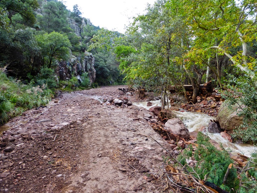
Damage to the canyon road between the Visitor Information Center and the South Fork confluence is extensive. Above the confluence, the road looks pretty much normal.

Here in particular, the road is severely undermined.

Extensive damage to the creekside pavement

Water flowing across the road above Idlewilde Campground

A large amount of debris is piled against the Stewart Bridge (the bridge at Stewart Campground), and one of the first orders of business is removing that stress to the bridge.

Still clinging to the bridge sign, about six feet up, are some possibly nervous invertebrates.
The next photo needs some explanation: I was standing toward the upstream end of the upper island of trees that the road used to go around on either side. Here the right hand side next to the creek has simply been carried off in the flood. From this point to the distant bend, the road is gone on this side of the island. The lefthand road remains intact.

Here this side of the road vanishes.
I took a side trip to Vista Point, curious whether it might be possible to see anything of the flood's aftermath, but only the usual canopy of green rises serenely above the flood.

Vista Point, looking up South Fork to the left of the prominence, and the main Cave Creek Canyon to the right.

Where South Fork meets the main canyon, the creek has demurely entered its channel again.

And now, come with me into South Fork.
Overall, the South Fork Road is in much better shape than the road through the main canyon, at least until a point above the two cabins, nearly a mile upstream from the gate. Geoff Bender made a pass through with a grader and improved the worst places.

The South Fork Road, showing evidence of the creek's rampage.

Both photos show the South Fork Road, a bit roughed up, but still in place.

This spot, to my untrained eye, looked to be the worst-damaged place on the South Fork Road.

A number of trees, like this Arizona Cypress, show scarring from the battering by debris carried in the floodwaters.

As in the main canyon, side canyons are still flowing. This one has been somewhat contained by the grader.

The South Fork Bridge appears to be in excellent shape, as do the cabins, from a quick glance.
Above the cabins, it's a different story. Here the creek jumped its channel to such a degree that the road now looks like a creekbed. I didn't go any further, but I'm told that the rocks continue for the next half-mile, to the old trailhead, where surprisingly the picnic ground and restroom are unscathed!

South Fork's new creek channel
I'll write a separate post on the Southwest Research Station. You'll be glad to see how fine it looks!

The cliff that I think of as the Easter Island Cliff towers tranquilly above the havoc.
Saturday, September 20, 2014
'Hard' Closure Coming to Cave Creek Canyon
On Monday, the Forest Service plans to institute a 'hard' closure of Cave Creek Canyon, meaning no entry by any means, including foot, except to canyon residents. The closure will most likely last for months. Thus, tomorrow is the last day when people can enter the canyon on foot.
I've learned a few other details: the Herb Martyr Road above the research station is washed out at Crystal Wash.
Columbus Electric laid a ground wire up the canyon, so that the research station now has electricity, but no fiber optics cable for Internet.
The South Fork Road is okay to the bridge and cabins (though in need of cleanup), but above the cabins it is gone. South Fork reclaimed it. Interestingly, the picnic area and bathroom at the trailhead are intact.
The water system to the FS campgrounds is broken.
Below the canyon, John and Morgan's straw bale home was flooded inside, and up to the top of the first layer of bales. They may need a hand in cleaning up!
Farther away to the east, the Peloncillos were as hard hit as the Chiricahuas. The county road south of Animas into the Animas Valley and Diamond A (Gray) Ranch has been washed out in some places. At the southern end, along Geronimo Trail (accessed from 15th Street in Douglas), the old wooden bridge supporting the road has been completely swept away. This means that access to Guadalupe Canyon, the Slaughter Ranch, and Clanton Canyon has been severed.
One positive note: the Chiricahua Leopard Frogs in Reed's pond at Cave Creek Ranch have survived!
I've learned a few other details: the Herb Martyr Road above the research station is washed out at Crystal Wash.
Columbus Electric laid a ground wire up the canyon, so that the research station now has electricity, but no fiber optics cable for Internet.
The South Fork Road is okay to the bridge and cabins (though in need of cleanup), but above the cabins it is gone. South Fork reclaimed it. Interestingly, the picnic area and bathroom at the trailhead are intact.
The water system to the FS campgrounds is broken.
Below the canyon, John and Morgan's straw bale home was flooded inside, and up to the top of the first layer of bales. They may need a hand in cleaning up!
Farther away to the east, the Peloncillos were as hard hit as the Chiricahuas. The county road south of Animas into the Animas Valley and Diamond A (Gray) Ranch has been washed out in some places. At the southern end, along Geronimo Trail (accessed from 15th Street in Douglas), the old wooden bridge supporting the road has been completely swept away. This means that access to Guadalupe Canyon, the Slaughter Ranch, and Clanton Canyon has been severed.
One positive note: the Chiricahua Leopard Frogs in Reed's pond at Cave Creek Ranch have survived!
Friday, September 19, 2014
Portal After Storm Odile
For friends of Portal everywhere, the bottom line is that everyone is okay, after the remnants of Hurricane Odile targeted the Chiricahua Mountains and the sister villages of Portal, Arizona, and Rodeo, New Mexico. At our home, we received 5.29" of rain over a four-day period, nearly all of it falling on Wednesday night. (Contrast that with 11" in an hour at Cabo San Lucas, where the hurricane made landfall!)
We woke yesterday morning to a roaring creek in our normally-dry arroyo, and found ourselves homebound, until the flash flood went down.

This morning, we joined neighbors Mark and Kathy Luckadoo to move rocks from the road down at the crossing, rake it, and smooth it until we could again drive through.


Then Alan and I went on a fact-finding foray.
This video taken yesterday showed Cave Creek flowing over the Portal Bridge. By today, the water had dropped below the bridge.


We were relieved to learn that our friends and neighbors appear all accounted for. Yes, everyone, the three houses below the research station, but above the South Fork confluence, all survived. Water ran over portions of the property, but spared the houses. Phone service and power lines are all down for much of the canyon, including parts of Portal.
The American Museum of Natural History's Southwest Research Station also survived, though I don't know the extent of the damage. Dawn Wilson, SWRS director, was able to come out today, in search of generators. All I've been told is that about 35 people are at the station, without drinking water. Included are about 20 students from Wales. The station has begun to evacuate their guests.
The major damage is to the area of the canyon below the confluence of South Fork and the main fork of Cave Creek, where the two vastly swollen streams converged. Flooding was definitely a problem above that confluence also, for these three homes and for the research station, but at least those places weren't swept away.
The bridges are intact, and today an engineer is evaluating their integrity for the US Forest Service.

Right now the road into Cave Creek Canyon is closed at the Visitor Information Center. Above the VIC, near the lower campgrounds where the road splits and goes on both sides of an island of trees, the righthand road has been completely washed away. The left is still passable. So repair to infrastructure, mainly to the road, will no doubt keep the canyon closed for a while, to all but the most essential traffic. Here is a link to photos of the damage above the road closure.
Folks have been concerned enough for Linda Jakse that I should say specifically––she's okay. We were told that the water rose above their patio to the back door, but no further. When it receded, the patio had even survived. The future gatherings that she and Paul will no doubt host on that patio are not in jeopardy.
A number of homes literally became islands in the storm, yet they all emerged intact, or mostly so. Peter and Mary Sue Waser have impressive video of the raging Cave Creek flowing around their entire home, but I'm not able to find it online. Here is a very similar video by Deborah Johnson. Amazingly, only a little water entered their utility room. Other creekside homes, including Gloria's, Howard and Carol's, Eskild and Susan's, Richard and Rose Ann's, Marge Fagan's, are all okay, although some outbuildings and wells are damaged. I haven't heard how Dinah's home fared, other than rumor that when last seen, it was high and dry.

From the Wasers' home, the river flowed down the main street of Portal, in front of the library and post office, before channeling back into the main creek bed.

Here is Laura Mullen's video of water flowing down the main street! (The same area is shown in Deborah Johnson's video above.) The people in the video are standing on the rock wall you see in the distance in this photo.
Cave Creek Ranch suffered damage to creekside cabins. This video taken at the lodge gives you some idea of the power of the raging creek.
In some places, Cave Creek now flows down a new primary watercourse.

Let's correct some misinformation reported by the sheriff's office and by national television: Gloria, our elder friend––and Portal's Honorary Mayor!––who was rescued from her home after Howard checked on her, was not up to her knees in water inside her home! Her situation was similar to the Wasers'. Water flowed all around her house but only a tiny bit got inside. However, her rescuers had to carry her through knee-deep water to retrieve her. She's fine now.
The Cochise County sheriff checked on people around Portal, to make sure everyone was accounted for. We do appreciate all the help from the sheriff's deputies, the Forest Service, the Border Patrol, and the county road folks, in dealing with the storm and its aftermath. Thank you!!
My information for Rodeo and the San Simon Valley is much sketchier. It did appear for awhile, however, that the ancient Pleistocene lake might reestablish itself to the north of Rodeo. The sheriff's Facebook page has a photo from State Line Road, along the AZ-NM border. Next, our valley gets to remember that it is, actually, a semidesert grassland.
We all appreciate your concern and well-wishes. We're drying out now! And the butterflies are out in force. Hummingbirds are still swarming, Violet-green Swallows and Swainson's Hawks are still migrating.

We woke yesterday morning to a roaring creek in our normally-dry arroyo, and found ourselves homebound, until the flash flood went down.
Flashing arroyo cuts across our road
(Photos by Narca)
This morning, we joined neighbors Mark and Kathy Luckadoo to move rocks from the road down at the crossing, rake it, and smooth it until we could again drive through.
Mark, Kathy, and Alan at work on the crossing
Test run over the crossing––yes!
Then Alan and I went on a fact-finding foray.
This video taken yesterday showed Cave Creek flowing over the Portal Bridge. By today, the water had dropped below the bridge.
Portal Bridge, with some damage
Water level on Friday at the Portal Bridge
The American Museum of Natural History's Southwest Research Station also survived, though I don't know the extent of the damage. Dawn Wilson, SWRS director, was able to come out today, in search of generators. All I've been told is that about 35 people are at the station, without drinking water. Included are about 20 students from Wales. The station has begun to evacuate their guests.
The major damage is to the area of the canyon below the confluence of South Fork and the main fork of Cave Creek, where the two vastly swollen streams converged. Flooding was definitely a problem above that confluence also, for these three homes and for the research station, but at least those places weren't swept away.
The bridges are intact, and today an engineer is evaluating their integrity for the US Forest Service.
Road closure into Cave Creek Canyon
Right now the road into Cave Creek Canyon is closed at the Visitor Information Center. Above the VIC, near the lower campgrounds where the road splits and goes on both sides of an island of trees, the righthand road has been completely washed away. The left is still passable. So repair to infrastructure, mainly to the road, will no doubt keep the canyon closed for a while, to all but the most essential traffic. Here is a link to photos of the damage above the road closure.
Folks have been concerned enough for Linda Jakse that I should say specifically––she's okay. We were told that the water rose above their patio to the back door, but no further. When it receded, the patio had even survived. The future gatherings that she and Paul will no doubt host on that patio are not in jeopardy.
A number of homes literally became islands in the storm, yet they all emerged intact, or mostly so. Peter and Mary Sue Waser have impressive video of the raging Cave Creek flowing around their entire home, but I'm not able to find it online. Here is a very similar video by Deborah Johnson. Amazingly, only a little water entered their utility room. Other creekside homes, including Gloria's, Howard and Carol's, Eskild and Susan's, Richard and Rose Ann's, Marge Fagan's, are all okay, although some outbuildings and wells are damaged. I haven't heard how Dinah's home fared, other than rumor that when last seen, it was high and dry.
Peter and Mary Sue's home became an island in the stream.
From the Wasers' home, the river flowed down the main street of Portal, in front of the library and post office, before channeling back into the main creek bed.
The main street in Portal, which became a river for awhile
Cave Creek Ranch suffered damage to creekside cabins. This video taken at the lodge gives you some idea of the power of the raging creek.
In some places, Cave Creek now flows down a new primary watercourse.
Across from the visitor center, Cave Creek has a new channel
Let's correct some misinformation reported by the sheriff's office and by national television: Gloria, our elder friend––and Portal's Honorary Mayor!––who was rescued from her home after Howard checked on her, was not up to her knees in water inside her home! Her situation was similar to the Wasers'. Water flowed all around her house but only a tiny bit got inside. However, her rescuers had to carry her through knee-deep water to retrieve her. She's fine now.
The Cochise County sheriff checked on people around Portal, to make sure everyone was accounted for. We do appreciate all the help from the sheriff's deputies, the Forest Service, the Border Patrol, and the county road folks, in dealing with the storm and its aftermath. Thank you!!
My information for Rodeo and the San Simon Valley is much sketchier. It did appear for awhile, however, that the ancient Pleistocene lake might reestablish itself to the north of Rodeo. The sheriff's Facebook page has a photo from State Line Road, along the AZ-NM border. Next, our valley gets to remember that it is, actually, a semidesert grassland.
We all appreciate your concern and well-wishes. We're drying out now! And the butterflies are out in force. Hummingbirds are still swarming, Violet-green Swallows and Swainson's Hawks are still migrating.
Bordered Patch on sunflowers at the Visitor Information Center
Monday, May 16, 2011
The Burn-out in Cave Creek Canyon
At this morning's briefing, the fire crews were told that the burn-out operation in the South Fork of Cave Creek Canyon is proceeding so far at a low intensity. That is very good news.

Right now our weather is transitioning from a high pressure system (with mild wind) to a major deep pressure system, now building in the Pacific Northwest. As that low pressure system moves across to the north of us, it will bring high winds again. So the crews are doing everything they can in the next two days to accomplish a low-intensity burn-out in critical habitats, before the wind can once again control what happens on the Horseshoe Two fire. The relatively light winds today are predicted for about 10 mph, with gusts to 25 or 30 mph. Winds continue to blow mainly from the southwest.
On the day of origin, Horseshoe Two ran north for about 7 miles during a single day, while in the grip of high winds. Right now the fire is about 2 miles from reaching the American Museum of Natural History's Southwest Research Station. The distance seems small to me (after seeing just what this fire did on the first day!), but the difference now is that the fire teams are in place and actively controlling the intensity and speed of the fire.

Yesterday a team working in the Herb Martyr area found a more direct checkline that they can use to moderate the fire. Repellant has been laid, and preparations continue today to back the fire into the basin. A backing fire burns moderately, with mostly low flame height, and achieves a beneficial burn. A fire rushing uphill is much more extreme and can torch entire stands of trees. So the crews are backing fire into South Fork and into the main Cave Creek Canyon. So far, so good. If work goes as planned, the backburn from the research station area may be lit off tonight.

Conditions remain very dry, and last night there was only a poor recovery of relative humidity, to about 15-16% overnight. It will be back in the single digits today. The fire behavior specialist exclaimed today that this fire continues to surprise him by the way it is following grass fuels, no matter what the wind does. This is anomalous behavior, due to the extreme dryness of fuels. Today's probability of ignition will range from around 80% when cloud cover is present, to 100% when the clouds burn off. (That is the measure of how likely a fire brand is to ignite more fire, should it land on fuel.) This anomalous behavior increases the risk to firefighters.
To the north, east, and south, the fire perimeter is holding very well and getting cold. The burn-out to Horseshoe Canyon road has been completed and the fire team is happy with how it went. Patrols check these areas regularly.

Most of the fire activity continues to be in the western region. Aerial ignition will continue along ridges in the vicinity of the fire's spread, to slow it by creating fires that back down the ridges to meet the main fire. Terrain in the high country is very difficult to work from the ground, so air operations are focused there. Snowshed Peak has burned, and the fire has not yet reached Chiricahua Peak.
Teams will be visiting Paradise today and evaluating the readiness of homes there, in case the fire gets away from us during the next high winds.
The statistics are these: 26,502 acres burned; 20% containment so far; 630 people working with the fire crews; and a total of $4.4 million spent so far.
A newspaper article which ran yesterday in a Tucson paper's online edition stated unequivocally that illegal immigrants started the Horseshoe Two fire. Apparently Border Patrol agents had tracked four illegal aliens to the point of origin of the fire. Much of the article was biased, but the assertion is correct that the fire was checked from burning into Portal on the first day by the large, heavily-grazed pasture of the Three Triangle Ranch, although the bulldozer line put in by the fire crew also was important. I walked part of the bulldozer line, and it is obvious that part of the fire stopped there.
My reporting on this blog is going to change after today. Alan and I are leaving for a trip to Eastern habitats. Raymond VanBuskirk will stay in our home while we are gone, and he, Peg Abbott, and Reed Peters will continue to attend the early morning briefings whenever possible, and send new information that I can post when internet connections allow. You will be treated to new perspectives on events here. I, however, won't have the same personal grasp on developments that comes from attending the meetings and observing firsthand how well a really skilled, professional fire team handles a crisis like this one. Together with my friends, we'll do our best to keep everyone informed.
Leaving right now is very difficult, yet I do need to get out of the smoke, and we have been planning to see faraway friends and family for some time. We are, at least, leaving the outcome in good hands.

After the briefing, with smoke from Horseshoe Two Fire
(Photos by Narca)
Right now our weather is transitioning from a high pressure system (with mild wind) to a major deep pressure system, now building in the Pacific Northwest. As that low pressure system moves across to the north of us, it will bring high winds again. So the crews are doing everything they can in the next two days to accomplish a low-intensity burn-out in critical habitats, before the wind can once again control what happens on the Horseshoe Two fire. The relatively light winds today are predicted for about 10 mph, with gusts to 25 or 30 mph. Winds continue to blow mainly from the southwest.
On the day of origin, Horseshoe Two ran north for about 7 miles during a single day, while in the grip of high winds. Right now the fire is about 2 miles from reaching the American Museum of Natural History's Southwest Research Station. The distance seems small to me (after seeing just what this fire did on the first day!), but the difference now is that the fire teams are in place and actively controlling the intensity and speed of the fire.

Fire map for May 16
Yesterday a team working in the Herb Martyr area found a more direct checkline that they can use to moderate the fire. Repellant has been laid, and preparations continue today to back the fire into the basin. A backing fire burns moderately, with mostly low flame height, and achieves a beneficial burn. A fire rushing uphill is much more extreme and can torch entire stands of trees. So the crews are backing fire into South Fork and into the main Cave Creek Canyon. So far, so good. If work goes as planned, the backburn from the research station area may be lit off tonight.

Today's major operations. Red dots are hotspots. Purple dots were hotspots, now cold.
Conditions remain very dry, and last night there was only a poor recovery of relative humidity, to about 15-16% overnight. It will be back in the single digits today. The fire behavior specialist exclaimed today that this fire continues to surprise him by the way it is following grass fuels, no matter what the wind does. This is anomalous behavior, due to the extreme dryness of fuels. Today's probability of ignition will range from around 80% when cloud cover is present, to 100% when the clouds burn off. (That is the measure of how likely a fire brand is to ignite more fire, should it land on fuel.) This anomalous behavior increases the risk to firefighters.
To the north, east, and south, the fire perimeter is holding very well and getting cold. The burn-out to Horseshoe Canyon road has been completed and the fire team is happy with how it went. Patrols check these areas regularly.

The black borders on this map are considered secure.
Most of the fire activity continues to be in the western region. Aerial ignition will continue along ridges in the vicinity of the fire's spread, to slow it by creating fires that back down the ridges to meet the main fire. Terrain in the high country is very difficult to work from the ground, so air operations are focused there. Snowshed Peak has burned, and the fire has not yet reached Chiricahua Peak.
Teams will be visiting Paradise today and evaluating the readiness of homes there, in case the fire gets away from us during the next high winds.
The statistics are these: 26,502 acres burned; 20% containment so far; 630 people working with the fire crews; and a total of $4.4 million spent so far.
A newspaper article which ran yesterday in a Tucson paper's online edition stated unequivocally that illegal immigrants started the Horseshoe Two fire. Apparently Border Patrol agents had tracked four illegal aliens to the point of origin of the fire. Much of the article was biased, but the assertion is correct that the fire was checked from burning into Portal on the first day by the large, heavily-grazed pasture of the Three Triangle Ranch, although the bulldozer line put in by the fire crew also was important. I walked part of the bulldozer line, and it is obvious that part of the fire stopped there.
My reporting on this blog is going to change after today. Alan and I are leaving for a trip to Eastern habitats. Raymond VanBuskirk will stay in our home while we are gone, and he, Peg Abbott, and Reed Peters will continue to attend the early morning briefings whenever possible, and send new information that I can post when internet connections allow. You will be treated to new perspectives on events here. I, however, won't have the same personal grasp on developments that comes from attending the meetings and observing firsthand how well a really skilled, professional fire team handles a crisis like this one. Together with my friends, we'll do our best to keep everyone informed.
Leaving right now is very difficult, yet I do need to get out of the smoke, and we have been planning to see faraway friends and family for some time. We are, at least, leaving the outcome in good hands.
Sunday, May 15, 2011
The Better Scenario
At tonight's public meeting, those gathered received a realistic appraisal of the current state of the Horseshoe Two fire, with an emphasis on how it can work if everything goes right.
As I said in an earlier post, the term "burn-out" is scary. And a burn-out is planned for South Fork and a portion of Cave Creek Canyon, as far down the canyon's north-facing slope as the main road. However, it is not a question of lighting a new fire that will rush upslope to meet the one now burning down. The Type 1 team's full skill is being directed at controlling the intensity of the fire and setting up checkpoints where the possibility exists to limit its spread.
Here is how that strategy is being applied in South Fork: the crews first laid down retardant where they wanted to limit the fire's spread, and then lit a fire along the unburned ridge above South Fork, opposite the burned slope. The newly set fire then burned slowly downhill and met the upcoming fire. After a day or two of applying this strategy, a mostly beneficial burn is being achieved in upper South Fork. We don't yet know the final outcome, but so far the plan is working in that spot.
South Fork is being burned out, but every attempt is being made to keep the burn at as low an intensity as possible.

The next step being prepared is aimed at checking the fire at the research station in Cave Creek Canyon. Lines are being laid, but it is too soon to light a backfire there just yet. First the fire burning towards Cave Creek has to get close enough that the backfire doesn't cause more problems than it solves when it is lit. So at the moment teams are waiting in that region until they judge the balance to be just right for meeting the oncoming fire. The backfiring could happen as soon as tomorrow, depending on developments.
The teams are under pressure to accomplish as much as possible before the next bouts of strong wind arrive. We've gained a little purchase here: the high winds originally predicted for Monday are now expected on Wednesday, so we've been gifted two extra days before the wind could again gust to 45 mph.
That is a quick update. I plan to attend tomorrow morning's briefing to the fire crews as well, and will photograph the most recent fire map for you.
As I said in an earlier post, the term "burn-out" is scary. And a burn-out is planned for South Fork and a portion of Cave Creek Canyon, as far down the canyon's north-facing slope as the main road. However, it is not a question of lighting a new fire that will rush upslope to meet the one now burning down. The Type 1 team's full skill is being directed at controlling the intensity of the fire and setting up checkpoints where the possibility exists to limit its spread.
Here is how that strategy is being applied in South Fork: the crews first laid down retardant where they wanted to limit the fire's spread, and then lit a fire along the unburned ridge above South Fork, opposite the burned slope. The newly set fire then burned slowly downhill and met the upcoming fire. After a day or two of applying this strategy, a mostly beneficial burn is being achieved in upper South Fork. We don't yet know the final outcome, but so far the plan is working in that spot.
South Fork is being burned out, but every attempt is being made to keep the burn at as low an intensity as possible.

Smoke from South Fork at sunset, May 15
(Photo by Narca)
The next step being prepared is aimed at checking the fire at the research station in Cave Creek Canyon. Lines are being laid, but it is too soon to light a backfire there just yet. First the fire burning towards Cave Creek has to get close enough that the backfire doesn't cause more problems than it solves when it is lit. So at the moment teams are waiting in that region until they judge the balance to be just right for meeting the oncoming fire. The backfiring could happen as soon as tomorrow, depending on developments.
The teams are under pressure to accomplish as much as possible before the next bouts of strong wind arrive. We've gained a little purchase here: the high winds originally predicted for Monday are now expected on Wednesday, so we've been gifted two extra days before the wind could again gust to 45 mph.
That is a quick update. I plan to attend tomorrow morning's briefing to the fire crews as well, and will photograph the most recent fire map for you.
Monday, June 21, 2010
Renewed Suppression of Horseshoe Fire
The Horseshoe Fire's continuing advance north has triggered new suppression efforts. It is still backing down drainages in South Fork Canyon, working its way toward the road. Suppression has become necessary to try to keep the fire from moving into the main Cave Creek Canyon. On the map, the deep red area burned yesterday, and the solid red line means that the fire is actively burning along those edges. The fire is considered out only along the solid black line. So far, 3230 acres have burned.
The fire map shows lumpy black chains (see small green arrows) where the proposed fire lines will be cut today, including retreat lanes for the fire crews. The lines will then be in place in case it becomes necessary to set a backfire that would burn upslope into the advancing Horseshoe. The lines are in the vicinity of the South Fork picnic area (blue box on left).

I've cropped this map less tightly, so that you can see the location of Portal, boxed in blue at the northeast corner of the map. A blue arrow points to the Southwest Research Station. Another small blue box is around Portal Peak to the east of the active fire.
Work on the water bars along Division R of the perimeter line was finished yesterday, an effort which should moderate erosion when the rains come.
Soon the team here will be transitioning to a new fire team under the command of Wayne Cook, and preparations for that change have begun. Today the Incident Command Post will be moving north along Highway 80 about one mile from its current position next to the Chiricahua Desert Museum. There they will have a real office building, in what Noel calls the "opera house." It's the former health food store. Stop in and say hi!
We extend our gratitude to the departing fire team––many thanks for a job well done!
Happy Solstice on this longest day of the year! Let's celebrate with a rain dance.
The fire map shows lumpy black chains (see small green arrows) where the proposed fire lines will be cut today, including retreat lanes for the fire crews. The lines will then be in place in case it becomes necessary to set a backfire that would burn upslope into the advancing Horseshoe. The lines are in the vicinity of the South Fork picnic area (blue box on left).

I've cropped this map less tightly, so that you can see the location of Portal, boxed in blue at the northeast corner of the map. A blue arrow points to the Southwest Research Station. Another small blue box is around Portal Peak to the east of the active fire.
Work on the water bars along Division R of the perimeter line was finished yesterday, an effort which should moderate erosion when the rains come.
Soon the team here will be transitioning to a new fire team under the command of Wayne Cook, and preparations for that change have begun. Today the Incident Command Post will be moving north along Highway 80 about one mile from its current position next to the Chiricahua Desert Museum. There they will have a real office building, in what Noel calls the "opera house." It's the former health food store. Stop in and say hi!
We extend our gratitude to the departing fire team––many thanks for a job well done!
Happy Solstice on this longest day of the year! Let's celebrate with a rain dance.
Sunday, May 30, 2010
The Horseshoe Fire
All of my fellow Portaleños, as well as the birding community, are following closely the development of the Horseshoe Fire, here in the Chiricahua Mountains of southeast Arizona. As of Saturday night, May 29, just over 1200 acres have burned in the heart of the Chiricahua Wilderness.

 And a 10-second exposure, both taken 10 miles from the fire
At last night's community meeting, fire supervisors told us that this promises to be a very difficult, very large fire, which will most likely burn until the monsoon rains arrive. If the fire burns to the perimeter line that firefighters hope to establish, it will be as large as 35,000 - 40,000 acres. (For comparison, the huge 1994 Rattlesnake Fire, which burned for a month, covered 29,000 acres.)
A team specializing in Type 1 fires––the most challenging––is here with 700 firefighters, including 19 Hot Shot teams. In all of the US there are 100 Hot Shot teams, so the commitment of nearly 20% of the nation's most proficient fighters of wildland fires indicates how seriously the fire experts are regarding the Horseshoe Fire. The Type 1 team here in Portal also responded to 9/11 in New York City.
The combination of terrain, fuel load and weather conditions makes this fire so difficult to handle––in the US, the fire supervisors told us, the Chiricahuas present as rugged a terrain as it's possible to find.
Fire perimeters have to be drawn so that the segments all connect to ring the fire. Given our rough terrain, it was impossible to make the perimeter any smaller. In steep, narrow canyons, flaming brands "jump" from one side of the canyon to the other, and so, in that situation, fire defeats all efforts to contain it.
Even after our good winter rains and snow pack, the moisture load of down fuels––logs etc––is low at only 6%. (Lumber for building usually has twice that moisture content.) However, the living trees are well hydrated and should withstand fire better than is often the case here. We hope to see a mostly low-intensity, mosaic burn which would benefit the habitat. We fear a high-intensity, stand-replacing, uncontrollable conflagration.
Fire supervisors see no way of keeping the fire out of South Fork, a major branch of Cave Creek Canyon renowned for its extraordinary biodiversity. To lower the impact, firefighters will concentrate on manipulating the fire when possible to lower its intensity, and thus avoid as much as possible the catastrophic, stand-replacing holocaust we experienced with the Rattlesnake (when fire burned from Methodist Camp all the way to the top at Rustler Park in 2 to 3 hours). Another goal is to protect the old growth riparian corridor along South Fork. Team members are very aware of its high biological value.
The fire investigators told us that the Horseshoe Fire was human-caused, and that it is virtually certain that illegal immigrants are responsible, once again. It began at Burro Springs, near the ridge between Horseshoe and South Fork Canyons. Deep frustrations were expressed at the meeting over the entire situation involving both illegal immigration and drug smuggling, and the suffering experienced by the border communities, which bear the brunt of a failed immigration policy and of the passage of many thousands of illegal entrants, in the form of fire ignitions, damage to pristine habitats, home break-ins, assaults, ambushes between rival cartels, and one recent murder. But that is another subject indeed....
Portal itself, while located right on the fire perimeter line, is in no imminent danger. Unfortunately, all of the homes up canyon from Portal fall inside the perimeter. For the moment, the American Museum of Natural History's Southwest Research Station is not in danger. Much depends on what the winds do during this coming month or two, and upon when the rains come––if they come. (Last year the monsoon essentially didn't come, and summer drought was intense.)
Two nights ago I drove with Gary Rosenberg and his group to go owling in the high Chiricahuas. Returning from Onion Saddle, we were sobered and deeply impressed by the expanse of twinkling hotspots spread beneath us, where trees stood as torches in the night, and the full moon rode above the wrack of smoke. Sleeping was difficult for me that night. It is hard to see this treasured canyon go through a crisis of these proportions, and to know that the research station and so many homes (including our own) are under threat. Yesterday as we helped friends to evacuate their cabin above the research station, a pair of Elegant Trogons was coming and going from their nest cavity, their home also in grave danger.

My sadness lifted a little when I remembered a grassland fire that Alan and I helped to fight in 1992 on the Gray Ranch. After the fire was under control, I walked back through smoking stubs of bunch grasses, and a single Grasshopper Sparrow hopped up onto a still-smoldering grass-snag in the midst of the black desolation, and began to sing.

Horseshoe Fire at 2 AM, May 30, a 30-second exposure
(Photos by Steve Cullen/Light Buckets)

A team specializing in Type 1 fires––the most challenging––is here with 700 firefighters, including 19 Hot Shot teams. In all of the US there are 100 Hot Shot teams, so the commitment of nearly 20% of the nation's most proficient fighters of wildland fires indicates how seriously the fire experts are regarding the Horseshoe Fire. The Type 1 team here in Portal also responded to 9/11 in New York City.
The combination of terrain, fuel load and weather conditions makes this fire so difficult to handle––in the US, the fire supervisors told us, the Chiricahuas present as rugged a terrain as it's possible to find.
Fire perimeters have to be drawn so that the segments all connect to ring the fire. Given our rough terrain, it was impossible to make the perimeter any smaller. In steep, narrow canyons, flaming brands "jump" from one side of the canyon to the other, and so, in that situation, fire defeats all efforts to contain it.
Even after our good winter rains and snow pack, the moisture load of down fuels––logs etc––is low at only 6%. (Lumber for building usually has twice that moisture content.) However, the living trees are well hydrated and should withstand fire better than is often the case here. We hope to see a mostly low-intensity, mosaic burn which would benefit the habitat. We fear a high-intensity, stand-replacing, uncontrollable conflagration.
Fire supervisors see no way of keeping the fire out of South Fork, a major branch of Cave Creek Canyon renowned for its extraordinary biodiversity. To lower the impact, firefighters will concentrate on manipulating the fire when possible to lower its intensity, and thus avoid as much as possible the catastrophic, stand-replacing holocaust we experienced with the Rattlesnake (when fire burned from Methodist Camp all the way to the top at Rustler Park in 2 to 3 hours). Another goal is to protect the old growth riparian corridor along South Fork. Team members are very aware of its high biological value.
The fire investigators told us that the Horseshoe Fire was human-caused, and that it is virtually certain that illegal immigrants are responsible, once again. It began at Burro Springs, near the ridge between Horseshoe and South Fork Canyons. Deep frustrations were expressed at the meeting over the entire situation involving both illegal immigration and drug smuggling, and the suffering experienced by the border communities, which bear the brunt of a failed immigration policy and of the passage of many thousands of illegal entrants, in the form of fire ignitions, damage to pristine habitats, home break-ins, assaults, ambushes between rival cartels, and one recent murder. But that is another subject indeed....
Portal itself, while located right on the fire perimeter line, is in no imminent danger. Unfortunately, all of the homes up canyon from Portal fall inside the perimeter. For the moment, the American Museum of Natural History's Southwest Research Station is not in danger. Much depends on what the winds do during this coming month or two, and upon when the rains come––if they come. (Last year the monsoon essentially didn't come, and summer drought was intense.)
Two nights ago I drove with Gary Rosenberg and his group to go owling in the high Chiricahuas. Returning from Onion Saddle, we were sobered and deeply impressed by the expanse of twinkling hotspots spread beneath us, where trees stood as torches in the night, and the full moon rode above the wrack of smoke. Sleeping was difficult for me that night. It is hard to see this treasured canyon go through a crisis of these proportions, and to know that the research station and so many homes (including our own) are under threat. Yesterday as we helped friends to evacuate their cabin above the research station, a pair of Elegant Trogons was coming and going from their nest cavity, their home also in grave danger.

Elegant Trogon in South Fork (Watercolor by Narca)
Subscribe to:
Posts (Atom)


 Posts
Posts

